Tocht Stappen Les Angles - Lac d'Aude - Photo
 dmatignon
dmatignon

Gebruiker

© OpenStreetMap contributors
Lengte
Lengte
13 km
Max. hoogte
Max. hoogte
2201 m
Positief hoogteverschil
438 m
Km-Effort
Km-Effort  
18,8 km
Min. hoogte
Min. hoogte
1798 m
Negatief hoogteverschil
439 m
Boucle
Boucle
Ja
Datum van aanmaak :
2019-08-05 06:48:52.271
Laatste wijziging :
2019-08-05 14:42:24.063

(0 Bericht)

Stappen
Stappen
5h35
Moeilijkheid : Medium

Scan deze QR-code om de tocht te openen in de SityTrail-applicatie

Gratisgps-wandelapplicatie

Logo SityTrail SityTrail

IGN / Geografische instituten

SityTrail uit de App Store downloaden SityTrail uit Google Play downloaden

Logo SityTrail SityTrail World

De wereld gaat voor u open

SityTrail uit de App Store downloaden SityTrail uit Google Play downloaden SityTrail op Huawei AppGallery downloaden

Over ons

Tocht Stappen van 13 km beschikbaar op Occitanië, Pyrénées-Orientales, Les Angles. Deze tocht wordt voorgesteld door dmatignon.

Beschrijving

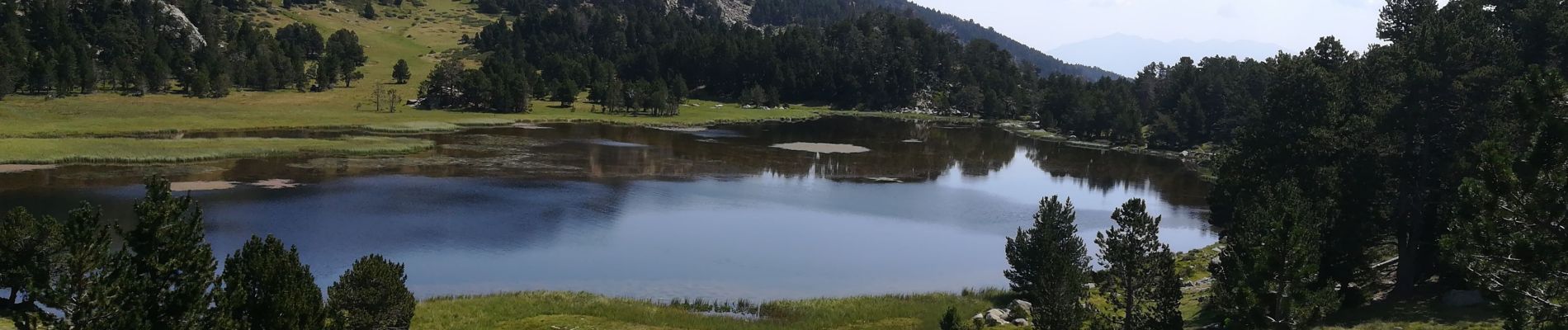
Randonnée partant du Pla del Mir jusqu'au lac d'Aude (source de l'Aude ?). vues sur les massifs du Canigou et du Carlit.

Hoogteprofiel

Foto's

Plaatsbepaling

Land:
France
Regio :
Occitanië
Departement/Provincie :
Pyrénées-Orientales
Gemeente :
Les Angles
Locatie:
Unknown
Vertrek:(UTM)
423277 ; 4712748 (31T) N.

Wandeltochten in de omgeving

Tocht Stappen Font-Romeu-Odeillo-Via - Coll del Pam lac des  Bouillouses - Photo
Stappen
jcmartin

Stappen

Medium
(2)
Font-Romeu-Odeillo-Via, Occitanië, Pyrénées-Orientales, France
13,3 km | 19,3 km-effort
4h 10min
Ja
Tocht Sneeuwschoenen Les Angles - Lac d Aude -Refuge Bernardi les Angles - Photo
Sneeuwschoenen
MarieFrancoise

Sneeuwschoenen

Medium
(1)
Les Angles, Occitanië, Pyrénées-Orientales, France
13,9 km | 19,1 km-effort
5h 44min
Ja
Tocht Stappen Les Angles - lac d'Aude  - Photo
Stappen
GUIDE
nadinebondoux

Stappen

Medium
Les Angles, Occitanië, Pyrénées-Orientales, France
13,8 km | 0 m-effort
5h 57min
Ja
Tocht Stappen Les Angles - Lac d'Aude en boucle - Photo
Stappen
GUIDE
nadinebondoux

Stappen

Medium
Les Angles, Occitanië, Pyrénées-Orientales, France
13,8 km | 19,9 km-effort
6h 8min
Ja
Tocht Stappen Les Angles - les Angles - Photo
Stappen
GUIDE
nadinebondoux

Stappen

Moeilijk
Les Angles, Occitanië, Pyrénées-Orientales, France
14,5 km | 20 km-effort
4h 58min
Neen
Tocht Stappen La Llagonne - llagonne - Calvet - Photo
Stappen
merencianoep

Stappen

Medium
(2)
La Llagonne, Occitanië, Pyrénées-Orientales, France
11,2 km | 14,2 km-effort
3h 0min
Neen
Tocht Noords wandelen Font-Romeu-Odeillo-Via - mauroux - Photo
Noords wandelen
oliviercaty

Noords wandelen

Medium
(2)
Font-Romeu-Odeillo-Via, Occitanië, Pyrénées-Orientales, France
11,2 km | 14,7 km-effort
1h 20min
Ja
Tocht Sneeuwschoenen Les Angles - lac d aude - Photo
Sneeuwschoenen
xav34830

Sneeuwschoenen

Heel gemakkelijk
(2)
Les Angles, Occitanië, Pyrénées-Orientales, France
14,5 km | 20 km-effort
Onbekend
Ja
Tocht Stappen Les Angles - boucle de la Balmette par le mont Llaret et le roc d'aude - Photo
Stappen
Axelloceane

Stappen

Medium
(2)
Les Angles, Occitanië, Pyrénées-Orientales, France
17,2 km | 28 km-effort
Onbekend
Ja


Sluiten
Mijn abonnementen